GW/SW-010, Craig y Llyn – 600m, 4 Points
We started the final weekend of our Brecons odyssey at Craig y Llyn. Parking is available either at the view point car park or there is plenty of room in the entrance to Cefn Glas which is a bit less exposed.
Having learnt the lesson last year, we avoided the footpath marked on the map and followed the road North to the corner where we picked up the track heading West to the hill. It is an easy route to find and this year due to the better weather it was not too muddy either.
 There was about fifty cm of snow lying on the top path in places but not enough to cause any problems. The trig point is still hidden deep in the woods so we set up on the highest bit of ground we could find on the edge of the track with a clear(ish) takeoff.
Having seen how well Richards MFJ Long Ranger aerial had performed previously, I have bought myself one, this was the first time I tried it out on a SOTA activation.
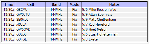
GW/SW-010, Log
The aerial worked well and we soon had six entries in the log so with a long weekend ahead packed up and returned to the car by the same route.
GW/SW-010, Journey Details
Date – 19th January 2019
Postcode – CF44 9UE
Parking – SN 923 027
Radio – Kenwood TH-D74
Antenna – MFJ 1714 LongRanger
Band – 144 FM
Contacts – 6
SOTA points – 4(+3)
Group – Myself + Richard
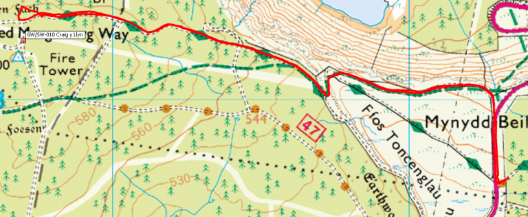
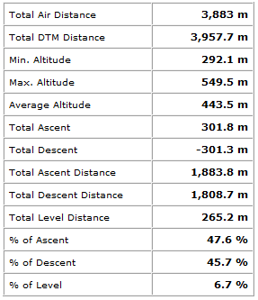
GW/SW-010, Walking Route Summary
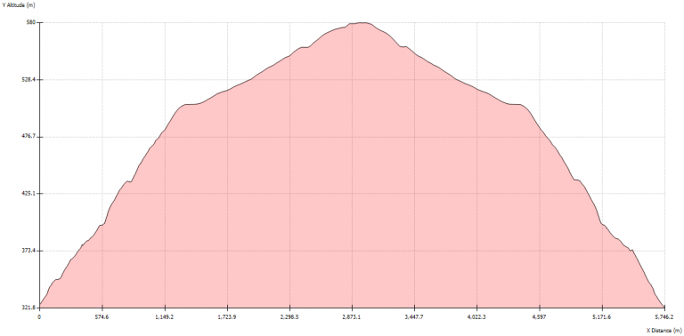
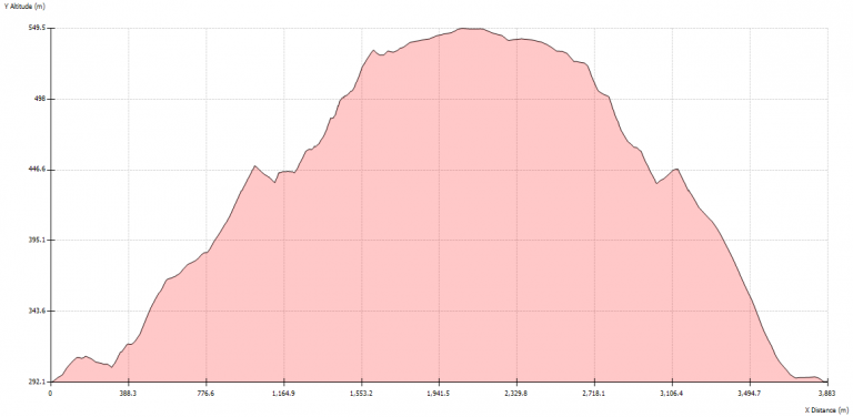
GW/SW-010, Altitude Profile
GW/SW-014, Mynydd Carn-y-cefn – 550m, 2 Points
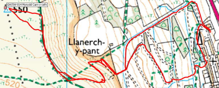
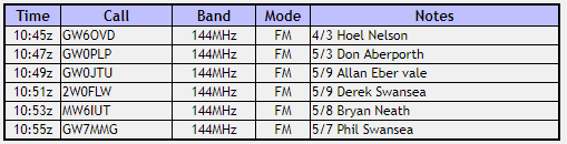
Onto Cefn yr Ystrad. Having struggled last year to find easy access to the mountain and then found it on the way back down, I thought it would not be a problem this year. Unfortunately I got it wrong again and ended up hacking up through the same scrubby wasteland behind the houses once again. At least this time I was able to avoid the steep grassy slope marked as a path on the map and instead found the footpath zig zagging it’s way up to the North of the marked path. 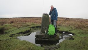 The top was in thick cloud so finding the trig point was a best guess but it soon appeared out of the mist and we were able to set up on the trig point inside the moat. Once again I used the MFJ and soon had seven contacts in the log.
GW/SW-014, Log
The return was uneventful and once again we found the easy route back to the car. Perhaps next year I will get it right?
GW/SW-014, Journey Details
Date – 19th January 2019
Postcode – NP13 3DD
Parking – SO 196 083
Radio – Kenwood TH-D74
Antenna – MFJ 1714 LongRanger
Band – 144 FM
Contacts – 7
SOTA points – 2(+3)
Group – Myself + Richard
GW/SW-014, Walking Route Summary
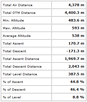
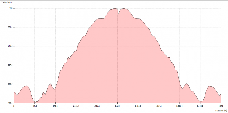
GW/SW-014, Altitude Profile
GW/SW-012, Coity Mountain – 578m, 2 Points
Just across the road from Cefn yr Ystrad is Coity Mountain.
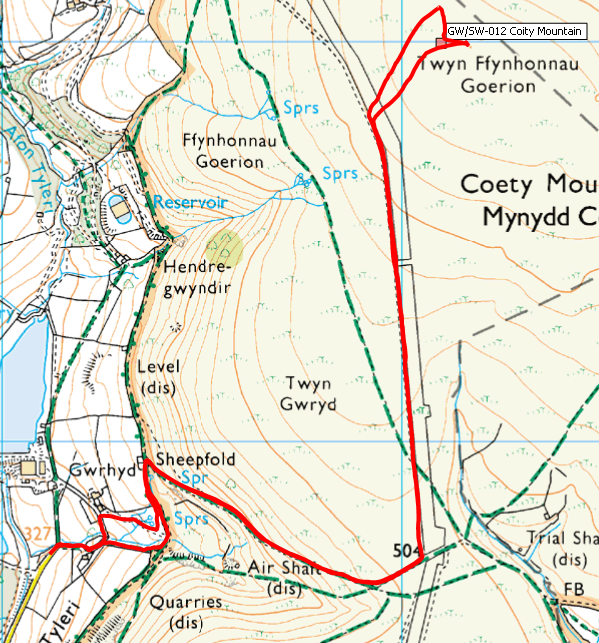
There is plenty of parking iat the picnic area car park on the North edge of Cwmtillery but I knew from last year that there is also room in a lay-by about another Km up the road to the North. We headed up there and found the lay-by empty so that saved us about 2Km of flat boring walking on tarmac. Again from experience last year I also knew that there was a path up on the North side of the valley which is much better than the one marked on the map up the centre. Once on top we were again in thick cloud. We followed the track as far as the bend then set off accross country to try and find the summit. There is a spot that is less than a metre higher than the surroundings which is the summit. It’s aboput 70m East of the point marked on the SOTA maps.
We set up on the summit and soon had nine entries in the log.
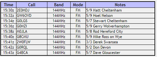
GW/SW-012, Log
The return to the car didn’t take long, all together a good day out SOTAing.
GW/SW-012, Journey Details
Date – 19th January 2019
Postcode – NP13 1LR
Parking – SO 221 067
Radio – Kenwood TH-D74
Antenna – MFJ 1714 LongRanger
Band – 144 FM
Contacts – 9
SOTA points – 2(+3)
Group – Myself + Richard
GW/SW-012, Walking Route Summary
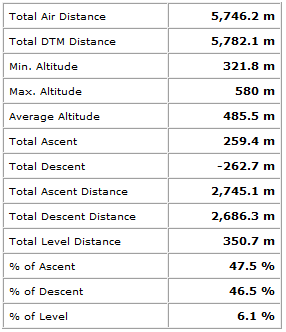
GW/SW-012, Altitude Profile